Where Is Area 51?
It sits in the silence of the Nevada desert… a white salt flat like a wound in the earth, encircled by razor wire and no-fly signs. For decades, that empty salt pan at Groom Lake has been both a material place and a myth: the epicenter of secret military bases, alleged UFO recoveries, classified projects, and whistleblower testimony.
The question: where exactly is Area 51, is simple. The answer is layered, guarded, and astonishingly traceable through modern maps and declassified records.
Table of Contents
Key Takeaways
- Area 51 coordinates: Groom Lake, Nevada: long used for U-2, OXCART, and secret aircraft testing.
- CIA declassified files (2013) confirm the base’s existence. Satellite imagery shows runways & hangars.
- UFO claims remain unverified: strongest evidence supports advanced aviation programs, not aliens.
👉Quick Reference Table: Area 51 Location
| Place | Common Coordinates | Nearest Town |
|---|---|---|
| Area 51 (Groom Lake) | 37.2350° N, 115.8111° W | Rachel, Nevada |
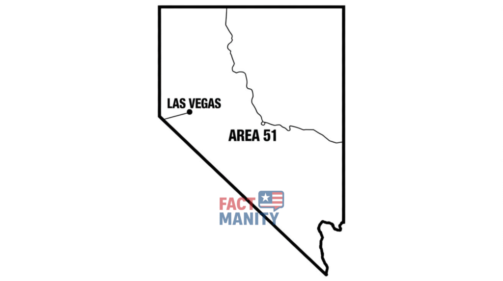
Quick Answer: Area 51 is centered on Groom Lake in southern Nevada, ~83 miles northwest of Las Vegas.
These decimal coordinates: 37.2350° N, 115.8111° W, place it inside the highly restricted Nellis Test & Training Range.
RECOMMENDED: You must read about the most conspiracy and secret blog based on “Area 51 Alien Pictures“.
More details on airspace restrictions can be found through the Federal Aviation Administration.
History & Timeline
Origins: Cold War Birth of a Secret Base
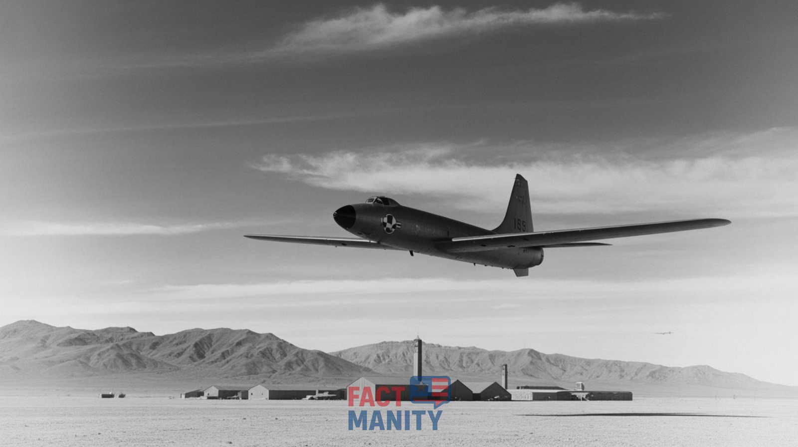
In the 1950s the United States needed a remote testbed for high-altitude spy planes. The CIA selected Groom Lake for its isolation and flat salt bed. Construction began quietly in the mid-1950s under Project AQUATONE: the program that produced the U-2. The base’s secrecy became policy, in 2013, the CIA released declassified records acknowledging Groom Lake’s existence and its role in U-2 and later A-12 OXCART testing.
According to the CIA official FOIA archive, several documents reference Groom Lake’s historical role.
From U-2 to Stealth: Decades of Classified Programs
Through the 1960s and beyond the site hosted ever-more-sensitive programs: OXCART (the A-12) in the 1960s, later aircraft and technologies through the 1970s–1990s. The salt flat’s runways, hangars and support infrastructure expanded behind fences and warning signs. Over time, pilots, engineers and guards became the living evidence of a place the government rarely named in public.
Government Involvement & Evidence
Exact Coordinates of Area 51
The most commonly quoted area 51 location coordinates are:
- Decimal: 37.2350° N, 115.8111° W
- DMS: 37°14’06” N, 115°48’40” W
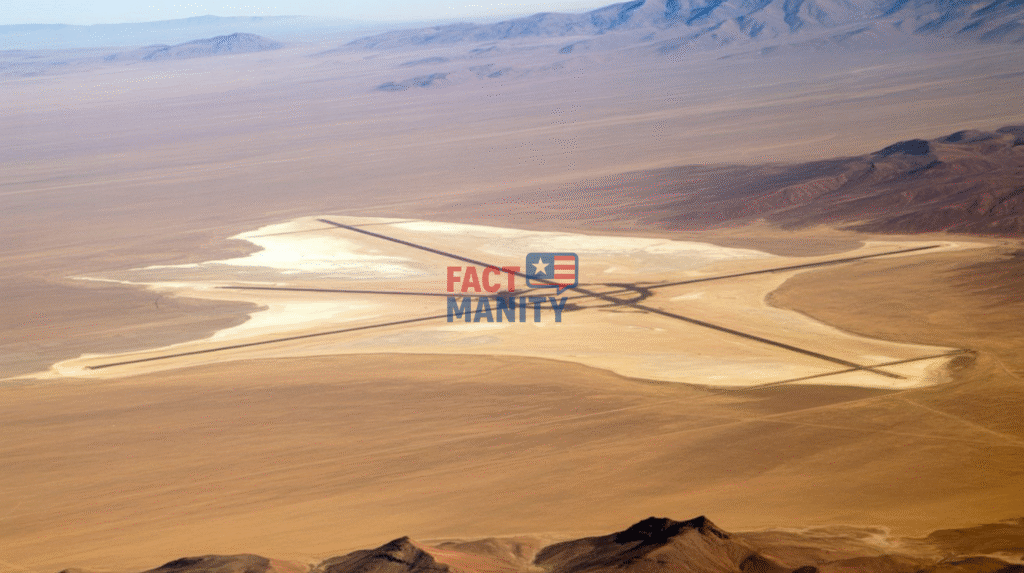
These coordinates point to Groom Lake, the dry lakebed where runways and hangars are visible on detailed imagery. Search terms like coordinate area 51 or coordinates of area 51 will return similar results in mapping tools.
Google Maps View
Area 51 on Google Maps is not hidden: you can find it if you know where to look, though the level of detail and labeling have varied. Google labels the area as “Groom Lake” in some contexts, and commercial map tiles show access roads, entrance gates and the unmistakable grid of runways.
Google Earth provides a richer experience: zooming in often shows hangars, support buildings, and the salt flat runway pattern. The existence of these views undermines the narrative that Area 51 is entirely invisible but public access is still guarded by legal restrictions on approach.
Satellite Images
Commercial satellites have photographed Groom Lake for years. If you search for area 51 satellite images or area 51 satellite view, you will find dated but verifiable images showing:
- Multiple long runways and taxiways
- Large hangars and security compounds
- Vehicle and aircraft movement at times corresponding to known test activities
These pictures of Area 51 are frequently used in investigative reporting to correlate personnel, construction and program timelines.
Theories vs Facts
Theory: UFOs, Alien Craft & Reverse Engineering
The more exotic theory holds that Area 51 houses recovered extraterrestrial craft and that scientists at nearby secret sites reverse-engineer alien technology. This narrative gained steam through whistleblowers and popular culture. Bob Lazar’s 1989 claims about an S-4 site under Papoose Mountain revitalized UFO lore, dramatic, persistent and controversial.

Fact: Classified Aircraft Testing & Advanced Programs
Documented evidence, however, provides a different core truth. Declassified documents from the CIA and other agencies show Groom Lake was used for:
- U-2 high-altitude reconnaissance development
- A-12/OXCART testing
- Later stealth and classified aviation projects
These are concrete, historically-documented programs supported by FOIA releases and official histories. The existence of the Advanced Aerospace Threat Identification Program (AATIP) and recent Pentagon admissions about UAP investigations add complexity, they do not prove an alien recovery at Groom Lake, but they do confirm sustained official interest in unexplained aerial phenomena.
Whistleblowers: Value & Limits
Whistleblower accounts matter. They direct attention, inspire FOIA requests and generate leads. But individual claims often lack corroboration. Investigators weigh these against documentary records the tension fuels public obsession with government conspiracies.
Leaked Documents & Evidence
Declassified CIA Files & FOIA Releases
In 2013 the CIA released historically significant documents that referenced Groom Lake by name and provided context for Cold War aviation projects. These declassified files are a touchstone: they confirm the existence of the facility and its central role in classified aircraft programs.
AATIP & Modern DoD Interest
Between 2007 and 2012 the Pentagon funded AATIP, a program that investigated UAPs. While AATIP does not point to alien tech at Area 51, it shows the Department of Defense formally studied unexplained sightings and that those conversations are no longer merely fringe. FOIA requests and public statements from former officials brought these details into the open.
What Leaked Images Show?
Leaked photos and satellite captures sometimes show aircraft parked in hangars and construction phases. They rarely reveal design schematics or the supposed “smoking gun” alien artifact. In short: the leaks confirm activity and secrecy… not necessarily extraterrestrial presence.
What’s Around the Base?
Geography & Nearest Towns
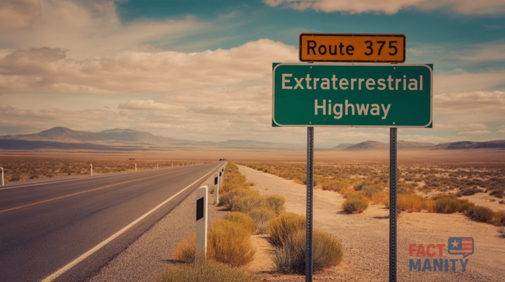
Area 51 sits in the Nevada desert near the small communities of Rachel and Alamo. Nevada State Route 375, the so-called “Extraterrestrial Highway”, runs nearby and has become a tourist draw. The base is surrounded by the vast Nellis Test and Training Range, an expanse of restricted airspace used for exercises and testing.
Restricted Zones
The base lies within special-use airspace and military-controlled land. The airspace designations (commonly referenced in public documents as parts of the Nellis complex) prohibit civilian overflight. Ground access is blocked by fences and security patrols. The Department of Defense enforces trespass laws rigorously. The combination of legal and physical barriers is part of why Area 51 remains off-limits.
Micro-Stories: Witnesses, Moments, Power
1. The pilot who would not talk: An aging test pilot once told a journalist that his flight out of Groom Lake felt like walking into a “sealed theater”… the runway, the black hangar doors, and a silence so total you could hear the desert breathe. He refused to sign a non-disclosure only once, and his career ended quietly soon after.
2. The declassified memo: A 2013 CIA document listed Groom Lake as a site tied to test flights. That simple line in an official file erased decades of speculation… but only reshaped the questions.
3. The Extraterrestrial Highway tourist: A family stopped at a roadside diner on State Route 375 and paid for a photograph beside a faded “Welcome to Rachel” sign. The diner knew every rumor, but kept receipts and a ledger of vehicles that came and went proof that the base’s secrecy was a local economy, as much as a national security posture.
Quick Facts
- Exact spot: Groom Lake, Nevada… commonly cited as 37.2350° N, 115.8111° W.
- Nearest highway: Nevada State Route 375, the “Extraterrestrial Highway.”
- Public image: Satellite photos and Google Earth show runways and buildings.
- Declassified proof: CIA FOIA releases (2013) acknowledge the site and its role in U-2/OXCART testing.
- Access: Ground and air access are restricted, trespassing is a federal offense.
Final Thoughts 💡
Area 51 is both a place on a map and a mirror for American secrecy. The coordinates 37.2350° N, 115.8111° W, anchor it in the real world and shows where is Area 51? The facts, drawn from declassified CIA files, FOIA releases and satellite images, show a site dedicated to classified aviation and testing. The theories of aliens, reverse engineering and covert extraterrestrial programs… persist because secrecy breeds speculation.
👉 For more inforamtion, also check National Geospatial-Intelligence Agency.
If you want to follow the trail further: explore declassified CIA records on Groom Lake, browse historical satellite imagery on Google Earth, and read FOIA releases tied to AATIP and DoD reports. For more deep dives into secret military bases, government conspiracies and whistleblower histories, check our related posts below and keep asking where the lines between secrecy and truth are really drawn.
For more investigations and myth-busting, explore our Weird Laws in Alaska guide.
Enjoyed this deep dive into Area 51?
Follow FactManity for more breakdowns of secret bases, government files, declassified documents, and UFO/UAP mysteries… all explained clearly, with evidence.
👉Also read the article about 10 Creepy Facts About America That Will Give You Chills!
FAQs
Can I see Area 51 on Google Maps?
Yes, you can find Groom Lake on Google Maps and Google Earth. Image clarity varies by provider and date, and Google does not label it “Area 51” in every dataset. Searching for the coordinates 37.2350° N, 115.8111° W will take you there.
What are the coordinates of Area 51?
The widely cited coordinates are 37.2350° N, 115.8111° W (decimal). These place the center of activities on Groom Lake in Nevada.
Is Area 51 connected to UFOs?
Area 51 features heavily in UFO lore, and many witnesses have claimed sightings and secrets. Factually, however, declassified records show the base primarily hosted secret aircraft testing. Some modern DoD programs have investigated UAPs, but no verified public evidence confirms alien technology at Groom Lake.
What happens if you trespass near Area 51?
Trespassing on or near the base is illegal and enforced by federal authorities. Fences, patrols and surveillance systems protect the perimeter. Penalties can include arrest and fines.
Are there satellite images or photos of Area 51?
Yes. Commercial satellite imagery and declassified photographs exist showing runways, hangars and support buildings. Many images are historical, updates depend on satellite tasking and commercial providers.